 English
 Italian
Please use this identifier to cite or link to this item:
http://hdl.handle.net/20.500.14008/28449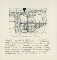
| DC Field | Value | |
|---|---|---|
| dc.date.accessioned | 2022-01-21T04:15:49Z | |
| dc.date.available | 2022-01-21T04:15:49Z | |
| dc.identifier.uri | http://hdl.handle.net/20.500.14008/28449 | |
| dc.description | <p>Plan of the city of Apamea: its main routes, its roman public areas and its churches. 1) Colonnade streets; 2) the agorà area; 3) Thermae; 4) circular building; 5) synagogue transformed into a church; 6) building with triclinios; 7) Cathedral; 8) Christian basilica; 9) theatre.</p> | |
| dc.language.iso | zxx | |
| dc.source | https://cmc.byzart.eu/items/show/68357/ | |
| dc.title | Apamea: Pianta della città con l'indicazione delle strade principali, delle aree pubbliche romane e delle chiese | |
| dc.type | image | |
| dc.type.physical | drawings (visual works) | |
| dc.rights.license | http://creativecommons.org/licenses/by-nd/4.0/ | |
| dc.relation.fond | UNIBO Bovini Archive | |
| dc.contributor.provider | AMSHistorica - University of Bologna | |
| dc.contributor.intermediateprovider | BYZART Project | |
| dc.contributor.dataprovider | University of Bologna | |
| dc.relation.place | Afāmiyā, Syria | |
| dc.type.magbiblevel | m | |
| dc.relation.project | BYZART Project | |
| dc.type.coar | Resource Types::image::still image | |
| item.cerifentitytype | Products | |
| item.fulltext | With Fulltext | |
| item.coartype | still image | |
| item.openairecristype | http://purl.org/coar/resource_type/c_c513 | |
| item.treefondsroot | BYZART. Byzantine art and archaeology | |
| item.openairetype | image | |
| item.grantfulltext | open | |
| Appears in Collections: | BYZART | |
Items in DSpace are protected by copyright, with all rights reserved, unless otherwise indicated.