 English
 Italian
Please use this identifier to cite or link to this item:
http://hdl.handle.net/20.500.14008/21936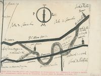
| Title: | Mappa della fine del XVIII sec. riguardante la delimitazione fra l'abbazia di S. Vitale a Ravenna ed i possedimenti della chiesa di S. Alberto | Start date: | 1775 | End date: | 1799 | Historical Period: | Post-Byzantine | Description: | Map of Ravenna concerning the delimitation between the abbey of S. Vitale in Ravenna and the properties of the church of S. Alberto Chronological details: End of the 18th c. AD |
Place: | Ravenna, Italy | Languages: | No linguistic content; Not applicable | Project: | BYZART Project | Fond: | UNIBO Bovini Archive | Physical type: | drawings (visual works) | Data provider: | University of Bologna | License: |  |
| Appears in Collections: | BYZART |
Show full item record
Items in DSpace are protected by copyright, with all rights reserved, unless otherwise indicated.